The Urban Planning – Energy Gap

India’s rapid urbanisation demands urban planning approaches that support mitigation, adaptation, and climate resilience at the local level. The scale of this planning opportunity is substantial. Under a Ministry of Housing and Urban Affairs (MoHUA) sub-scheme, GIS-based master planning was being implemented in 456 towns across 35 States and Union Territories[1]. Separately, an AMRUT pilot was established to support the preparation of Local Area Plans (LAPs) and Town Planning Schemes (TPS) in 25 States/cities[2]. As these statutory planning processes expand, the spatial decisions embedded within them will shape urban energy demand and infrastructure requirements for decades. While climate action plans and policy commitments have proliferated in recent years, translating these ambitions into routine planning and development decisions remains a persistent challenge. Much of this challenge stems from the disconnect between city-scale climate objectives and the local planning processes through which urban form, infrastructure, mobility, and development outcomes are ultimately shaped.
Currently, in most cities, zoning and development control regulations govern floor area and built form, “locking in” critical determinants of energy demand and renewable energy generation potential at an early stage of the land-use planning process. This is not an abstract risk. In modelled Indian residential scenarios, Lall and Sethi[3] found that a four-storey development scenario resulted in annual emissions of 0.84 tCO₂ per capita, compared with 1.01 tCO₂ per capita in their 12-storey scenario. With rooftop solar, emissions fell to 0.56 tCO₂e per capita in the four-storey scenario, compared with 0.92 tCO₂e per capita in the 12-storey scenario. Statutory planning instruments – such as LAPs and TPS – do not systematically consider overall energy demand, local energy-generation potential, or grid resilience. Once the urban form is “locked in”, opportunities for neighbourhood-scale energy self-sufficiency and distributed energy systems become severely constrained, and later system upgrades become costly and disruptive. This problem is exacerbated by a lack of accessible, data-informed tools aligned with these planning processes, which limits urban planners’ capacity to factor in energy transition implications into spatial decisions. For residents, these decisions can shape everyday thermal comfort, reliance on mechanical cooling, electricity demand, and the quality of shared outdoor space[4][5].
A Decision Support System Tool to enable Sustainable Urban Transitions
We all use Google Maps to show us the best route to get from Point A to Point B. Similarly, planners would benefit greatly from a tool that lets them test different development scenarios to find the best pathway to a low-carbon future.
This is the gap that the Decision Support System (DSS) tool is designed to close. An interactive tool such as the one developed by the ps Collective helps integrate decarbonisation considerations into statutory planning mechanisms, enabling planners to test the implications of development choices before they are embedded in the built form. This tool enables urban planners to generate, visualise, and iteratively test alternative development pathways. Spatial, environmental, and policy trade-offs can be evaluated across metrics such as energy use, density, and heat exposure. The tool is designed for urban local bodies, development authorities, and spatial planning practitioners who need to evaluate alternative scenarios before regulations and capital investments are locked in. The tool works at the local level, where decisions about development intensity, such as FSI, are made. It is designed to align with existing planning paradigms, functioning as an analytical layer atop conventional planning layers such as land-use and mobility.
The energy module is one of the several integrated layers within this tool. It allows planners to test and compare different land-use scenarios. It assesses the impact of alternative planning regulations, and understands how each option could affect electricity demand and load curves, local energy generation, demand-supply mismatch, including the impact of new loads such as electric vehicles.
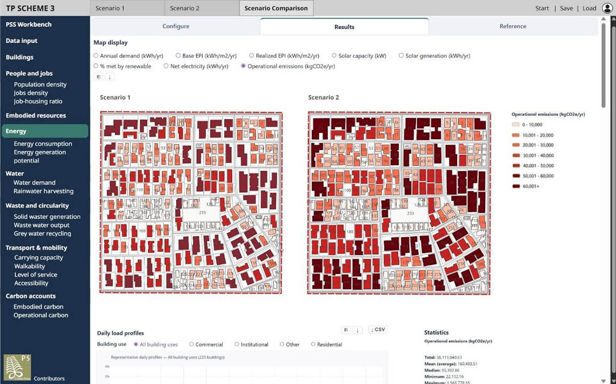
Fig. 1: A sample of the tool interface. Users can input an area plan and analyse it for various metrics, such as energy demand, energy generation potential, population density, water consumption, and waste generation.
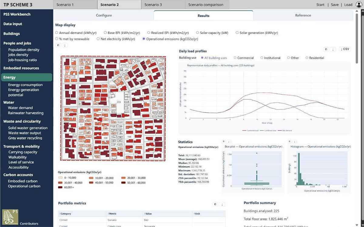
Fig. 2: A tweak in the building ground coverage and height limits could have a large impact on building volumes, and correspondingly, on operational emissions. The tool facilitates such scenario comparison to understand the potential effects of such regulatory changes.
This approach brings energy planning into the early stages of land-use planning, and helps identify opportunities to meet future energy needs through local solutions (such as rooftop solar and other distributed renewable-energy resources) rather than relying only on network expansion as urban areas grow.
The conceptual framework and working prototype of the tool support our argument that integrating forward-looking load and resource metrics into prevalent statutory planning processes is essential and possible for the reliable and cost-effective scaling of India’s clean energy transition and mitigating future system risk, rather than playing catch-up by retrofitting buildings and grids. The tool can empower cities to design neighbourhoods, precincts, and wards, that are not only liveable and efficient but also aligned with national climate commitments.
Urban planning in India operates in data-scarce contexts, and planning officials have limited resources to overcome these challenges. This tool enables quick and easy visualisation, scenario testing, and spatial decision-making based on planning and environmental factors such as land use, mobility, population density, energy demand, energy generation potential, water consumption, and waste generation. The tool is built on open-source frameworks, and can start with minimal data inputs (e.g., plot boundaries, road networks) and grow in complexity. Users can gradually add development control layers (FSI, ground coverage), infrastructure data, and performance metrics (persons/m², kWh/HH, GHG emissions, etc.).
Institutionalising the Use of the Tool
Climate-responsive planning depends not only on the availability of climate data, analytical models, or digital tools, but also on the ability of planning institutions to systematically generate, evaluate, interpret, and apply evidence throughout the planning, implementation, and monitoring cycle. Decision support workflows provide one practical mechanism for operationalising planning intelligence. However, successful institutionalisation of such a process requires complementary policy design – specific statutory mandates, fiscal embedding, and civil service reform – to compel the routine use of such systems within statutory planning mechanisms. The institutionalisation of climate-responsive local area planning ultimately requires the institutionalisation of planning intelligence, and our efforts are a step in that direction. The next step is to test and refine the tool with planning institutions in live statutory-planning contexts. For planners, this would mean being able to see the energy consequences of alternative development controls before they are approved.
About the authors:
Saket Sarraf | Principal, ps Collective
Dr. Saket Sarraf is an architect and urban planner with over 25 years of experience in sustainable development and the built environment. He is Founder and Principal of ps Collective, a research based consultancy focusing on policy research, energy efficiency, and decision-support systems working at the intersection of buildings, cities and energy systems.
Vidya Bhamidi | Architect, Urban Planner
Vidya Bhamidi is an architect and urban planner with over a decade of experience working across transportation, housing, energy, water, and climate resilience. Her work focuses on turning ambitious plans into systems that institutions can actually implement. She is particularly interested in how cities respond to climate risk, infrastructure constraints, and rapid urban growth, and in building practical approaches that connect policy, planning, investment, and on-the-ground delivery.
Ninad Shroff | Architect, Urbanist
Ninad Shroff is an architect and urbanist with over two years of experience in research, design, and policy analysis. He has worked with urban planning think tanks, community-focused NGOs, and ecologically-driven architecture firms. He is passionate about solving complex problems in cities with a data-driven, equity-based, and practical approach, and enjoys debating on all things urban.
References:
[1] Ministry of Housing and Urban Affairs (2022). Formulation of GIS based Master Plan for AMRUT Cities. https://www.pib.gov.in/Pressreleaseshare.aspx?PRID=1805773®=48&lang=2
[2] Town and Country Planning Organisation, Ministry of Housing and Urban Affairs (n.d.). Sub Scheme on Local Area Plan and Town Planning Schemes. http://tcpo.gov.in/sub-scheme-local-area-plan-and-town-planning-schemes
[3] Lall, A. B., & Sethi, G. (2024). Operationalising energy sufficiency for low-carbon built environments in urbanising India. Buildings and Cities, 5(1), 645–661. https://journal-buildingscities.org/articles/10.5334/bc.440
[4] Rawal et al. (2022). Adaptive thermal comfort model based on field studies in five climate zones across India. Building and Environment, 219, 109187.https://www.sciencedirect.com/science/article/pii/S0360132322004231?via%3Dihub
[5] Dutta et al. (2020). Understanding the Relationship Between Density and Neighbourhood Environmental Quality – A Framework for Assessing Indian Cities. IIETA. https://www.iieta.org/journals/ijsdp/paper/10.18280/ijsdp.150711
Sarraf, S; Bhamidi, V; Shroff, N. (2026). Breaking the Urban Lock-in: Integrating Energy Transition and DERs into India’s Statutory Planning Workflow. Presented at Accelerating Clean Energy (ACE) 2026 annual research convening by WRI.
Sarraf, S; Vyas, S; Mittal, A. (2025). Bridging Climate Goals and Local Action: A Planning Support System for Urban Resilience. Presented at Energise 2025 by AEEE.

